![](/images/other/stat-length.png)
![Randonnée Marche La Chapelle-en-Valgaudémar - Valgo 2 - J4 : refuge de Vallonpierre - Photo](https://media.geolcdn.com/t/1900/400/7d8b3fae-a844-4002-9f15-89f8c2cf8663.jpg&format=pjpeg&maxdim=2)
Valgo 2 - J4 : refuge de Vallonpierre
ETMU5496
Utilisateur
![Longueur](/images/other/stat-length.png)
Longueur
19 km
![Altitude max](https://static1.geolcdn.com/siteimages/upload/files/1508320355ic_sort_altitude_max_24dp.png)
Altitude max
2611 m
![Dénivelé positif](https://static1.geolcdn.com/siteimages/upload/files/1508320355ic_sort_den_pos_24dp.png)
Dénivelé positif
1192 m
![Km-Effort](/images/other/stat-length.png)
Km-Effort
35 km
![Altitude min](https://static1.geolcdn.com/siteimages/upload/files/1508320355ic_sort_altitude_min_24dp.png)
Altitude min
1518 m
![Dénivelé négatif](https://static1.geolcdn.com/siteimages/upload/files/1508320355ic_sort_den_neg_24dp.png)
Dénivelé négatif
1192 m
![Boucle](https://static1.geolcdn.com/siteimages/upload/files/16400158638029165_repeat_loop_refresh_sync_direction_icon.png)
Boucle
Oui
Date de création :
2021-06-30 06:19:44.0
Dernière modification :
2021-07-06 15:58:01.257
![Marche](https://static1.geolcdn.com/sitytour/trail-icons/101.png)
5h31
Difficulté : Difficile
![Scannez ce code QR pour ouvrir la randonnée dans l'application SityTrail](https://capi.geolives.com/qq0zvz2zws4bq2lad0pu/sitytour/trails/2845578/qr.png?size=200)
Application GPS de randonnée GRATUITE
À propos
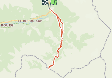
Randonnée Marche de 19 km à découvrir à Provence-Alpes-Côte d'Azur, Hautes-Alpes, La Chapelle-en-Valgaudémar. Cette randonnée est proposée par ETMU5496.
Description
Départ sous le chalet du Gioberney Les clos le chemin du ministre Refuge de Vallonpierre col de Vallonpierre retour par même itinéraire avec une variante le long de la sévéraisse
Localisation
Pays :
France
Région :
Provence-Alpes-Côte d'Azur
Département/Province :
Hautes-Alpes
Commune :
La Chapelle-en-Valgaudémar
Localité :
Unknown
Départ:(Dec)
Départ:(UTM)
285212 ; 4968331 (32T) N.
Commentaires
Randonnées à proximité
![Marche Marche](https://static1.geolcdn.com/sitytour/trail-icons/101.png)
Refuge de Chalance
Marche
Difficile
(1)
La Chapelle-en-Valgaudémar,
Provence-Alpes-Côte d'Azur,
Hautes-Alpes,
France
![](/images/other/stat-length.png)
7,5 km | 22 km-effort
5h 1min
![](https://static1.geolcdn.com/siteimages/upload/files/16400158638029165_repeat_loop_refresh_sync_direction_icon.png)
Oui
![Randonnée Marche La Chapelle-en-Valgaudémar - Tour du Vieux Chaillol 2/5 - Du Gîte Le Casset au Refuge de Vallonpierre - Photo](https://media.geolcdn.com/t/375/260/ext.jpg?maxdim=2&url=https%3A%2F%2Fservices.sitytrail.com%2FGeolivesWS%2FDownloadMedia.ashx%3FTrailID%3D110181%26Media%3D5395_2.jpg)
![Marche Marche](https://static1.geolcdn.com/sitytour/trail-icons/101.png)
Tour du Vieux Chaillol 2/5 - Du Gîte Le Casset au Refuge de Vallonpierre
Marche
Moyen
(1)
La Chapelle-en-Valgaudémar,
Provence-Alpes-Côte d'Azur,
Hautes-Alpes,
France
![](/images/other/stat-length.png)
11,8 km | 24 km-effort
4h 30min
![](https://static1.geolcdn.com/siteimages/upload/files/16400158638029165_repeat_loop_refresh_sync_direction_icon.png)
Non
![Randonnée A pied La Chapelle-en-Valgaudémar - Refuge du Pigeonnier - Photo](https://media.geolcdn.com/t/375/260/ce7c5daf-99aa-48e8-b5ea-75a2997b18fd.jpg&format=jpg&maxdim=2)
![A pied A pied](https://static1.geolcdn.com/sitytour/trail-icons/100.png)
Refuge du Pigeonnier
A pied
Difficile
La Chapelle-en-Valgaudémar,
Provence-Alpes-Côte d'Azur,
Hautes-Alpes,
France
![](/images/other/stat-length.png)
7,8 km | 18,6 km-effort
4h 13min
![](https://static1.geolcdn.com/siteimages/upload/files/16400158638029165_repeat_loop_refresh_sync_direction_icon.png)
Oui
![A pied A pied](https://static1.geolcdn.com/sitytour/trail-icons/100.png)
Refuge de Vallonpierre
A pied
Difficile
La Chapelle-en-Valgaudémar,
Provence-Alpes-Côte d'Azur,
Hautes-Alpes,
France
![](/images/other/stat-length.png)
13,8 km | 24 km-effort
5h 33min
![](https://static1.geolcdn.com/siteimages/upload/files/16400158638029165_repeat_loop_refresh_sync_direction_icon.png)
Oui
![A pied A pied](https://static1.geolcdn.com/sitytour/trail-icons/100.png)
Refuge de Chabournéou
A pied
Moyen
La Chapelle-en-Valgaudémar,
Provence-Alpes-Côte d'Azur,
Hautes-Alpes,
France
![](/images/other/stat-length.png)
10,2 km | 17,1 km-effort
3h 53min
![](https://static1.geolcdn.com/siteimages/upload/files/16400158638029165_repeat_loop_refresh_sync_direction_icon.png)
Oui
![Randonnée Marche La Chapelle-en-Valgaudémar - Chalet-hôtel de Gioberney - boucle Lac du Lauzon - 7.2km 480m 4h30 (1h) - 2018 06 27 - Photo](https://media.geolcdn.com/t/375/260/ext.jpg?maxdim=2&url=https%3A%2F%2Fservices.sitytrail.com%2FGeolivesWS%2FDownloadMedia.ashx%3FTrailID%3D999345%26Media%3Dfix__20180627142404.jpg)
![Marche Marche](https://static1.geolcdn.com/sitytour/trail-icons/101.png)
Chalet-hôtel de Gioberney - boucle Lac du Lauzon - 7.2km 480m 4h30 (1h) - 20...
Marche
Difficile
La Chapelle-en-Valgaudémar,
Provence-Alpes-Côte d'Azur,
Hautes-Alpes,
France
![](/images/other/stat-length.png)
7,2 km | 13,6 km-effort
4h 30min
![](https://static1.geolcdn.com/siteimages/upload/files/16400158638029165_repeat_loop_refresh_sync_direction_icon.png)
Oui
![Randonnée Marche La Chapelle-en-Valgaudémar - Vallée de la Séveraisse - AR sur le GR54 du Rif du Sap jusqu'au Clot - 6km 190m 2h20 - 2018 07 04 - Photo](https://media.geolcdn.com/t/375/260/ext.jpg?maxdim=2&url=https%3A%2F%2Fservices.sitytrail.com%2FGeolivesWS%2FDownloadMedia.ashx%3FTrailID%3D998794%26Media%3Dfix__20180704131615.jpg)
![Marche Marche](https://static1.geolcdn.com/sitytour/trail-icons/101.png)
Vallée de la Séveraisse - AR sur le GR54 du Rif du Sap jusqu'au Clot - 6km 19...
Marche
Moyen
La Chapelle-en-Valgaudémar,
Provence-Alpes-Côte d'Azur,
Hautes-Alpes,
France
![](/images/other/stat-length.png)
6 km | 8,5 km-effort
2h 20min
![](https://static1.geolcdn.com/siteimages/upload/files/16400158638029165_repeat_loop_refresh_sync_direction_icon.png)
Oui
![Randonnée Marche La Chapelle-en-Valgaudémar - Parking du Crépon - AR Gioberney Refuge de Vallonpierre - 16km 850m 7h35 (50mn) - 2018 07 03 - Photo](https://media.geolcdn.com/t/375/260/b31b91c8-a8b7-444d-8b10-22f70d1d8991.jpg&format=jpg&maxdim=2)
![Marche Marche](https://static1.geolcdn.com/sitytour/trail-icons/101.png)
Parking du Crépon - AR Gioberney Refuge de Vallonpierre - 16km 850m 7h35 (50m...
Marche
Difficile
La Chapelle-en-Valgaudémar,
Provence-Alpes-Côte d'Azur,
Hautes-Alpes,
France
![](/images/other/stat-length.png)
16 km | 27 km-effort
7h 35min
![](https://static1.geolcdn.com/siteimages/upload/files/16400158638029165_repeat_loop_refresh_sync_direction_icon.png)
Oui
![Randonnée Marche La Chapelle-en-Valgaudémar - PARC NATIONAL DES ECRINS: REFUGE DU PIGEONNIER - Photo](https://media.geolcdn.com/t/375/260/63f96214-74ba-423a-b110-db305c3e34c6.jpg&format=jpg&maxdim=2)
![Marche Marche](https://static1.geolcdn.com/sitytour/trail-icons/101.png)
PARC NATIONAL DES ECRINS: REFUGE DU PIGEONNIER
Marche
Moyen
La Chapelle-en-Valgaudémar,
Provence-Alpes-Côte d'Azur,
Hautes-Alpes,
France
![](/images/other/stat-length.png)
9,4 km | 21 km-effort
3h 22min
![](https://static1.geolcdn.com/siteimages/upload/files/16400158638029165_repeat_loop_refresh_sync_direction_icon.png)
Oui